The subject of the strategic importance of the Jordan Valley comes up from time to time in geopolitical discussions and is a key issue in determining what future arrangements between Israelis and Palestinians will be.
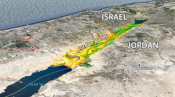
The valley itself is a geological trough from the Sea of Galilee on its north to the Dead Sea at its southern end, nestled between mountain ranges to the west on the Israeli side and to the east on the Jordanian side. The Jordan River meanders down the center of the valley and empties into the Dead Sea, which, at its southern end, stretches the valley to make it some 200 km (120 miles) long and roughly 10 km (6 miles) wide on average. It is known as the lowest valley on the planet, some 400 meters (1300 feet) below sea level at its maximum.
Historical Background
For four centuries the region was controlled by the Ottoman Empire until World War One when British forces took over. Modern warfare was still in its infancy and the area is rife with strategic heights that control the approaches not just to Jerusalem, but also the tactical routes leading to and from other regional centers like Damascus and Amman. The British army exploited those strategic areas to defeat the local Ottoman forces.
Following WW1, the valley, which had been a single geopolitical entity under the Ottomans, was split up the middle by the world powers. The British Mandate controlled the area to the west of the Jordan River and the eastern side fell under the rule of what would eventually become the Kingdom of Jordan. Thus, the term “West Bank” is literally the west side of the river and when Israelis talk about the “Jordan Valley” they generally are referring to the western half of the valley.
The 1947 UN Partition Plan that called for Jewish and Arab states, assigned the northern half and the southern tip of the Jordan Valley to Israel. The 1948 ceasefire left Israel in control of those areas: the agricultural area from the kibbutzim at the south end of the Galilee to just south of the city of Beit She’an and the southern end of the Dead Sea including Kibbutz Ein Gedi. The rest, including the West Bank, fell under Jordanian control where between 1948 and 1967 Palestinian terrorists used those areas as a staging ground for attacks on Israel.
Related reading: In Focus: How The UN Partition Plan Led to Israel’s Birth
For Israel, the Jordan Valley historically has been a defensive source of deep concern. In the War of Independence in 1948, attacking Arab armies brought tanks not just from neighboring Jordan and Syria, but from Iraq, whose border is less than 350 km (150 miles) from the valley. This was also a fear in 1967 when the Arab states were threatening to annihilate the young country.
The status of the Jordan Valley changed dramatically when Jordan joined the fighting in the 1967 war, but was defeated. Israeli forces captured the entire West Bank of the Jordan River along with its strategic assets.
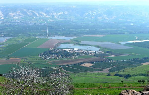
The valley, however, did have some positive breakthroughs despite the official state of war between Jordan and Israel. During the 1950s, the two countries reached an American-brokered deal to share the limited water resources of the Jordan Valley. While that agreement spurred agricultural development and fostered more off-the-radar Israeli-Jordanian cooperation, it also cut to a trickle the amount of water reaching the Dead Sea. More than half a century later, the two neighbors are now confronted by dangerously low water levels that have created an environmental headache on both sides of the border.

Advent of the Oslo Accords
The advent of the Oslo Accords in the 1990s for several years gave the impression that a permanent resolution to the strife appeared to be in the making. At the time, the issue of the Jordan Valley and its vexing security challenges was only one of the issues challenging negotiators. The Israeli position at the time was that it would retain security control of the Jordan Valley for 12 years, with the area eventually coming under full Palestinian control.
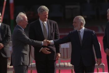
A key geopolitical change was the 1994 Israeli-Jordanian peace treaty. The two sides further entrenched water cooperation, resolved some minor border issues and Jordan absolved itself of any sovereignty claims over the West Bank. The peace treaty is supported by the government of Jordan, but disdained by many ordinary Jordanians.
That treaty was strained in 1997 when a Jordanian soldier opened fire on a group of Israeli schoolgirls visiting the “Island of Peace,” a park on the border that was originally Israeli land, but ceded to Jordan for peace. Seven young girls were murdered and Jordan’s King Hussein made an unprecedented condolence call to the families of the victims. However, many Jordanians at the time praised the killings and when the soldier was released from prison in 2017 he received a hero’s welcome.
The valley comprises both territories recognized as being under Israeli sovereignty and the areas captured in the 1967 war, most of which is considered Area C – under Israeli military control. The largest area under Palestinian control (Area A) is the town of Jericho with some twenty thousand inhabitants. The entire valley holds about 58,000 Palestinians and 50,000 Israelis.
Related reading: Do You Know Your Area A, B and C?
Jordan Valley: Strategic Value
Israeli security experts look at the Jordan Valley as providing “strategic depth.” Without the West Bank, Israel at some points is only 15 km (9 miles) wide. Although modern conventional warfare has changed, downplaying the fear of an armored attack from the east, the last two decades has shown a dramatic increase in the strategic threat of short-range rockets particularly from Gaza. The Hamas terrorist organization controls Gaza and does not hide its desire to take over the West Bank, nor its total rejection of the peace process.
Following the 1967 Six Day War, cabinet minister Yigal Allon proposed to annex most of the Jordan Valley as part of a plan to either return the populated part of the West Bank to Jordan or make it autonomous. There have been variations on that plan since, none of which have been taken seriously. In an apparent election ploy before the September 2019 vote, Prime Minister Benjamin Netanyahu pledged to annex parts of the valley, but that failed to gain him more public support.
An assessment in 2019 by the respected Institute for National Securities Studies at Tel Aviv University noted that “the U.S. administration accepts the core demand of Prime Minister Netanyahu for freedom of action for Israeli security forces in all territory west of the River Jordan … in accordance with Israel’s security needs.”
In the United States, the Congressional Research Service prepares background reports on a regular basis for the Congress, detailing issues affecting Israel and Israel-US relations. One of those reports concluded that for the Jordan Valley “…Israel may not be willing to agree to phase out its presence—largely owing to recent historical instances in which Israeli military withdrawal from southern Lebanon (2000) and the Gaza Strip (2005) led to the entrenchment of adversarial Islamist militants armed with rockets that have hit Israeli population centers and remain capable of doing so.”
Liked this article? Follow HonestReporting on Twitter, Facebook, Instagram and TikTok to see even more posts and videos debunking news bias and smears, as well as other content explaining what’s really going on in Israel and the region. Get updates direct to your phone. Join our WhatsApp and Telegram channels!
Featured image: vectors by Freepik; map via Google Earth; peace treaty CC BY-NC-SA Government Press Office; Qasr El Yahud via YouTube/Marie BLANC DURAND;