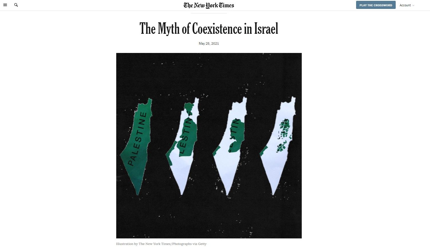
If you’ve spent some time reading about the Arab-Israeli conflict on the internet, you have most likely encountered a series of maps supposedly outlining how Palestinian land ownership has dramatically declined over the last century.
Seen variously under titles such as “Palestinian loss of land,” “Shrinking Palestine” or, more recently, “Palestinian Historic Compromise,” the maps are striking.
They are also grossly misleading and poison the conversation about Israel. Here’s why.
Most people assume maps are accurate: charts that have been meticulously drawn up to faithfully depict the land they represent. But we often fail to consider their potential to mislead. The ability of maps to convey three-dimensional realities on a two-dimensional plane is more constrained than we realize. Moreover, the title above the map – like a headline – frames the way we understand it.
When taken out of context, maps can easily be used to manipulate or deceive. While this deception is immediately apparent to those familiar with the particular region’s history, such maps can nevertheless successfully influence the perception of uninformed people.
The next time you see these maps online, feel free to quote from part of this article, or to simply link to this page.
Whatever you do, don’t let the lie go unchallenged.
Misleading Terminology
First, some background information. Historically, the word “Palestinian” did not refer to Arabs living in the region, but to the region itself. Some 100 years ago, the land was administered by the British, and its inhabitants were Jewish, Christian and Muslim – all of whom were identified as “Palestinian.” However, for most, their primary identity was not their nationality, but their religion.
Indeed, many Arabs bristled at being called “Palestinian,” voicing strong opposition to the label. Instead, they saw themselves first and foremost as Arabs or Muslims. Only in the mid-1960s was the word co-opted to mean Arabs.
Hence, before 1948, it would not have made sense to talk about Palestinians as opposed to Jews. The population was divided into two primary groups: Jewish and Arab.
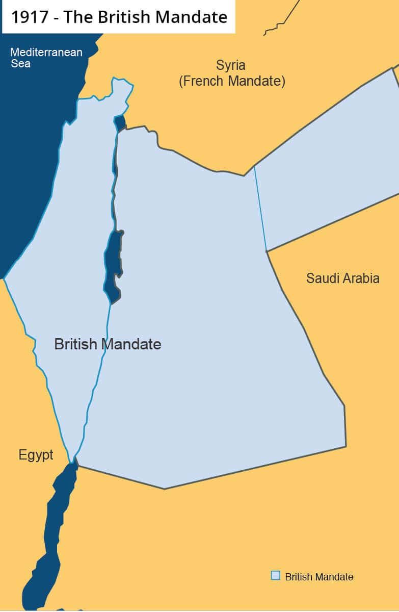
This makes sense because a sovereign Palestinian state never existed. Therefore, there were no “Palestinian lands.” Rather, the land was part of the Mandate for Palestine, a geographical area controlled by the British after the collapse of the Ottoman Empire at the end of the First World War.
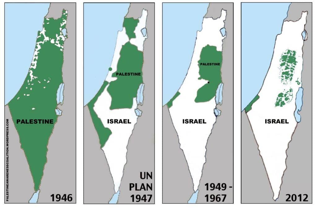
It’s worth looking at the maps one at a time to properly understand the depth of the deception. Refer to them above, while attached below are a series of more accurate maps, corresponding to each map in the graphic above.
Map #1: ‘Historic Palestine’ / ‘Palestine 1946’
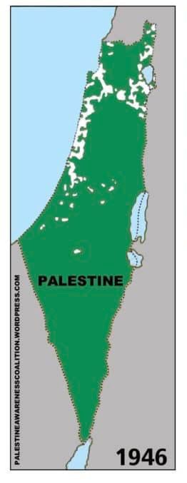 While there are multiple versions of the map series online, most start with one of two graphics. Either an image of “historic Palestine” is depicted, or one referring to the land in 1946.
The first version, purporting to show “Historic Palestine,” is filled with green, indicating that it is one self-governing state. In the period preceding British rule, the region was administered by Turkey and stretched into modern-day Lebanon and Syria. The area at the time was never a sovereign entity in its own right, and the boundaries shown in such a map do not reflect the boundaries of the region as administered by the Ottomans, nor as they appeared under previous rulers.
The more common version features a map claiming to show “Palestine” in 1946. Colored mostly in green, there are a number of small patches of white. While these are not labeled, the white color is used in later maps to indicate areas controlled by Israel. However, the Jewish state only came into existence in 1948. In other words, the white here evidently denotes areas where Jews lived. By that logic, then, surely there should be patches of green in later maps indicating the presence of Arabs living in Israel. By conflating Jews in this map with Israel in later maps, the map fundamentally misleads with regard to the issue it supposedly illustrates: the borders of a “Palestinian” state.
Related Reading: What Was the Land of Israel Like Before 1948?
Furthermore, if the white areas are where Jews lived, then surely the green areas should show where Arabs lived, not just the rest of the land. Much of the land was uninhabited – the Negev desert, for example. The absence of Jews in these areas was matched by an absence of Arabs. A more accurate rendering of this map would make clear where Arabs lived, where Jews lived, and where nobody lived.
In fact, there were about a million Arabs in the land, alongside roughly half a million Jews. But because the green area is vastly larger than the white area — even though much of it was unpopulated — it utterly twists the historical reality.
Finally, the map also conveniently leaves out a much larger area, about 70 percent of Mandatory Palestine, that had earlier been part of the region administered by Britain but was demarcated in the 1920s and transferred to Arab control (see accompanying map above). The Balfour Declaration had earlier indicated that a Jewish homeland would be established within this region, but the vast majority of it went on to become the independent state of Transjordan, later known simply as Jordan – a Muslim Arab state whose population mostly consists of Arab Palestinians. By leaving out this region from the first map, the graphic shows only a fraction of the land that was originally part of Mandatory Palestine and ignores the fact that most of the area was given to Arabs some twenty years before the United Nations voted to partition the land again into two states.
Map #2: “Palestine 1947”
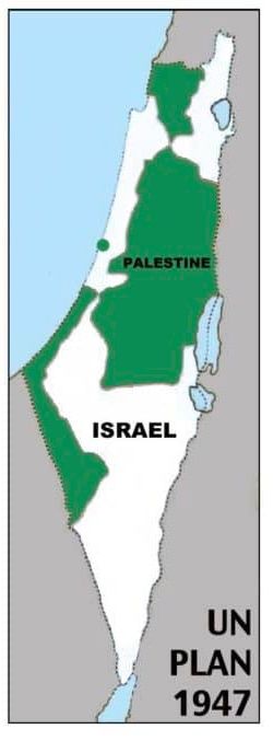 This map is perhaps the most mendacious and is easiest to debunk of them all. Whereas the other maps show realities on the ground, albeit in a highly misleading manner, this graphic shows something that was never a reality: it shows a plan that remained strictly theoretical.
After the conclusion of WWII, the United Nations was faced with the quandary of what to do with the competing claims for the Holy Land, then administered by Britain. In response, a dedicated committee, known as the United Nations Special Committee on Palestine, was formed in May 1947. After some months of meeting with local representatives, it attempted to solve the problem of the two factions vying for the same territory with a plan to divide the land into two states: One Arab and one Jewish. This proposal, later known as the Partition Plan, was put to the vote at the UN on 29 November 1947.
Related Reading: In Focus: How The UN Partition Plan Led to Israel’s Birth
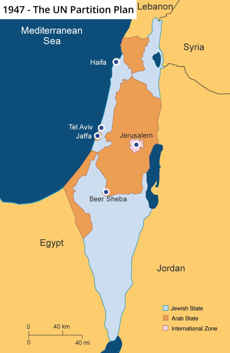
Although the vote was passed by a majority of 33 to 13 (with 10 abstentions), it was never realized. While the Jewish community in Palestine joyously celebrated the UN’s decision to ratify the reestablishment of a Jewish homeland, the local Arab population immediately took up arms in a bid to prevent Israel’s birth.
Had the Arabs accepted this plan as the Jews did, decades of conflict and bloodshed could have been prevented. Instead, they gambled on their own future by attacking their Jewish neighbors, only to lose and end up with less land than that which was due to be allocated to them under the UN plan. The Arabs only have their own leadership to blame for passing up this opportunity.
The claim on this map that it illustrates the Palestinian “compromise” is beyond a mere inaccuracy. It’s an outright lie. The map is also highly misleading when it appears under titles claiming to show a Palestinian “loss of land,” as this map does not reflect the reality of land distribution at any time. Including a theoretical plan alongside actual maps is profoundly disingenuous.
Map #3: “Palestine 1967” or “Palestine 1949-1967”
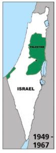
What some refer to as the “map of 1967” does not actually show borders, but armistice lines Israel signed with Jordan and Egypt in 1949 after its War of Independence. Under international law, these armistice lines are not borders – they merely mark the lines that are agreed by both sides when fighting ends. However, whereas Israeli territory is accurately portrayed, the areas labeled as “Palestine” were actually ruled by other states. Conveniently, the map does not show that Jordan retained control of the West Bank, while Egypt held on to the Gaza Strip.
In 1967, the Arab armies once again amassed on Israel’s borders with the intent to attack and destroy the Jewish state. Egypt also closed the Straits of Tiran to Israeli shipping; an act of war. Israel then launched a successful preemptive strike on Egypt, which led to an all-out war with Egypt and Syria. While Israel appealed to Jordan to not join the fighting from the east, the country nevertheless attacked, expecting a swift Arab victory and the possibility of claiming all of Jerusalem as Jordanian territory.
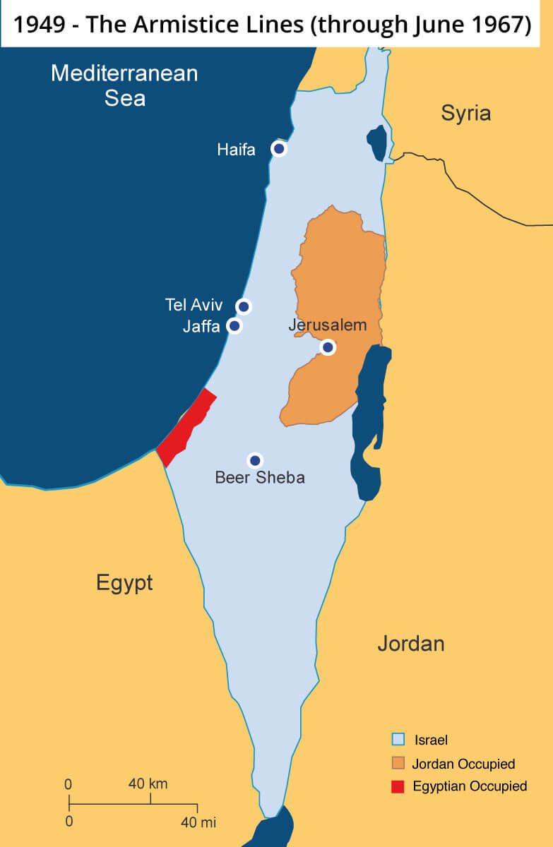
To say things didn’t work out the way the Arabs expected would be an understatement. When the battle ended, Israel’s victory was decisive. The Jordanian army fled to the eastern bank of the Jordan River. Egypt not only lost control of Gaza, but the entire Sinai Peninsula. The Golan Heights, from which Syria shelled the Galilee, was in Israeli hands.
Immediately after the war, Israel offered to return the territories it captured in return for peace. The Arab response to Israel’s land for peace offer is known as the Three Nos:
- No peace with Israel
- No recognition of Israel
- No negotiations with Israel
Once again, the Palestinians could have had much of this land, but their refusal to make peace cost them dearly.
Map #4: “Modern Day Palestine”
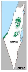 This map shows almost the complete opposite of the first one. Whereas in the latter the open areas were marked as “Palestine,” in this map Israel’s presence is presumed everywhere that lies open. This makes sense inside Israel’s internationally recognized boundaries, which is undisputedly one entity. But it makes considerably less sense when referring to the West Bank, or Judea and Samaria, which is largely administered by Israel.
Related Reading: Why are Israeli Settlements the ONLY ‘Obstacle to Peace’?
While the Jewish state is responsible for civil control of 82% of the land, that does not mean that Israel has built all over it. Whatever one’s position on the right of Jews to build in the West Bank, the reality is that Jewish communities in the area, also referred to as settlements, constitute only a fraction of the land. (According to the right-wing Yesha Council, settlements sit on only 1% of the West Bank, albeit their jurisdiction covers some 40% of the total region). Israel has also not asserted permanent control of the region, instead leaving its final status open to negotiations, should the Palestinians choose to enter peace talks.
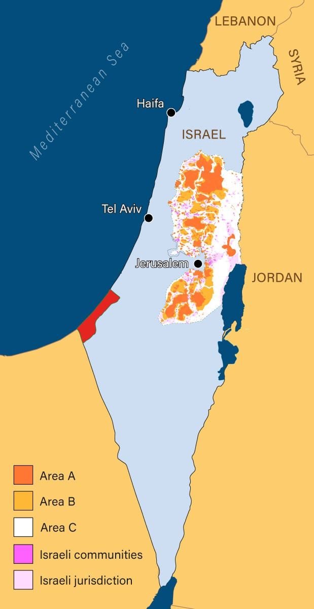
Following the Oslo Accords in the 1990s, Israel agreed to withdraw its military gradually from Palestinian areas and to transfer security responsibility of those areas to the Palestinian Legislative Council and the Palestinian Authority police. This took place within the context of the division of the West Bank and Gaza into different sectors, classified as Areas A, B and C, thus handing the Palestinians political control for the first time in their history.
In Conclusion
Though these popular maps purport to show how territorial control over the land has shifted over time, they are fundamentally misleading. The inclusion of plans which remained strictly theoretical, as is the case with the UN Partition Plan and, in more recent versions, the Trump peace plan, are outright lies. Furthermore, mixing different classifications of maps, with some indicating Jewish and Muslim populations, and some referring to Israel and Palestinian-controlled territories, makes any meaningful comparison impossible.
Finally, these maps omit something crucial which anti-Israel activists are rarely willing to admit: Israel has made a series of withdrawals from land in a bid for peace. From the 1957 Sinai withdrawal to the Disengagement of Forces Agreements in 1974 and 1975, and the pullback of forces in 1979 and 1982 following the Israeli-Egyptian peace treaty, Israel has long sought to make compromises for the benefit of its neighbors, especially when there has been a reasonable chance of making peace.
More recently, Israel pulled its forces from most of Lebanon in 1985 and completed that withdrawal from its remaining posts in southern Lebanon in 2000. For this, it received nothing but a barrage of Hezbollah fire in return. In between, and despite immense misgivings by much of the Israeli public, the Israeli government recognized the Palestinian Authority and, for the first time, transferred civil control over major Palestinian cities in the West Bank and Gaza. In 2005, Israel pulled out thousands of civilians and the soldiers protecting them from over twenty communities in the Gaza Strip.
In the eyes of the Israeli public, that move for peace backfired spectacularly, with rockets fired from Gaza frequently raining down on Israeli towns in the South. What is unarguable, however, is that such moves are not represented in these maps. Instead, their one-dimensional, misleading story obscures the simple reality that there was never a sovereign Palestinian state and, contrary to the maps’ central message, Palestinians actually enjoy greater sovereignty today than at any other point in their history.
Liked this article? Follow HonestReporting on Twitter, Facebook, Instagram and TikTok to see even more posts and videos debunking news bias and smears, as well as other content explaining what’s really going on in Israel and the region. Get updates direct to your phone. Join our WhatsApp and Telegram channels!