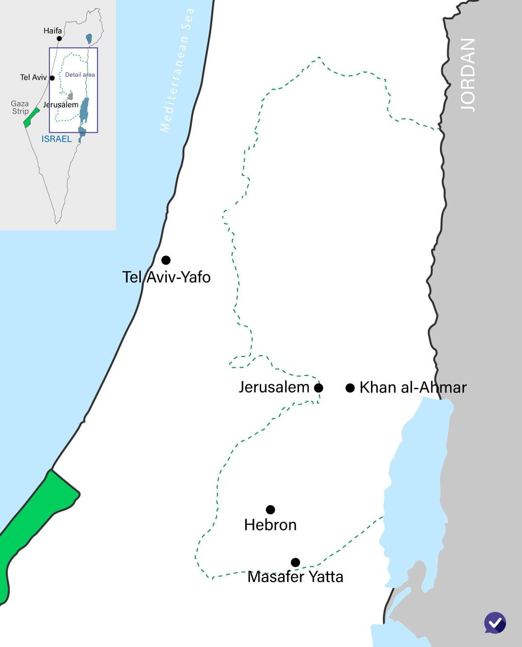
Masafer Yatta and Khan al-Ahmar are two small Bedouin enclaves in the West Bank that the State of Israel is seeking to evacuate, which has generated a considerable amount of international media attention.
Major news organizations such as the BBC, CNN and Washington Post have published in-depth reports about the controversy surrounding these two areas. But how much is really known about the history behind the controversy? And how much of Israel’s perspective is presented in these reports?
Here is an in-depth look at the histories of Masafer Yatta and Khan al-Ahmar as well as an analysis of Israeli perspectives concerning their evacuation.
Masafer Yatta
Summary:
- Located in the southern Hebron Hills, Masafer Yatta was traditionally used for grazing and agriculture, with no permanent residents.
- In the early 1980s, the IDF established Training Zone 918 in the area.
- In 1997, locals took the IDF to court in order to revoke its designation as a training area.
- Most structures in Masafer Yatta have been built illegally over the past 20 years and serve to create facts on the ground.
- In 2022, the Israeli High Court of Justice decided in favor of the IDF.
Located in the southern Hebron hills, Masafer Yatta is composed of 12 villages/hamlets that are sparsely inhabited by local Bedouins. Currently, the 36-square-kilometer (14-square-mile) area is populated by roughly 1,000 inhabitants (approximately 5% of the area size of New York City with around 0.01% of its population).
During the Ottoman, British and Jordanian eras, Masafer Yatta was considered to be public land and was used primarily by Bedouins and locals from the larger town of Yatta as a grazing ground for their animals as well as for agricultural development.
During this time, there were no permanent structures on the land, and people spending a more extended period of time in the area would temporarily live in special cave dwellings.
In the early 1980s, the IDF requisitioned this area to serve as a training ground for soldiers and it became Training Zone 918 (sometimes also referred to as “Firing Zone 918”).
For almost 20 years, the IDF was able to conduct military exercises in the zone unimpeded while also allowing locals to continue to graze their flocks as well as providing them with advanced notice when soldiers would be using live fire.
Related Reading: Beyond Biased Headlines: Disproving the Israel ‘Ethnic Cleansing’ Charge
In 1997, local Palestinians petitioned the Israeli High Court of Justice to revoke the designation of the area as a training zone and to remove any impediments to their access to it.
At the same time, illegal permanent structures began to be built throughout the zone without the permission of the Israeli authorities. According to the Oslo Accords, Israel has full authority within Area C (which includes Masafer Yatta) until a final status agreement is reached with the Palestinian Authority.
This illegal construction was first contained to three sections but later expanded to become the 12 that exist today (the IDF firing zone affects 8 out of 12 of these hamlets).
In 2000, following an attempt by the IDF to evacuate these newly inhabited areas, the Israeli High Court instructed the IDF to put a stop to any evacuations while also forbidding any construction at the site until the Court had reached its final decision.
While there were no evacuations during this time, illegal construction of permanent structures continued unimpeded.
According to military sources, the vast majority of permanent structures were illegally built over the last 20 years, with many structures standing empty and serving solely to create a false impression that the territory is more heavily inhabited.
In the South Hebron Hills today at Training Area 918 (often referred to as Masafer Yatta).
Able to view the full picture on the ground, which is very different to that presented on social media and in the international press. (1/2) pic.twitter.com/ePrKR6TiH3
— Lt. Col. Richard Hecht (@LtColRichard) November 20, 2022
As the court case carried on for years, the IDF made a number of compromise gestures towards the inhabitants of the area, such as allowing access to the site on weekends, Jewish holidays and a full two months of the year, but these were rejected by those claiming residency in the area.
Additionally, during this time period, the IDF okayed the permanent settlement of the northwest section of the firing zone, which includes two hamlets.
In May 2022, the Israeli High Court of Justice decided in favor of the IDF and allowed for the legal dismantling of the permanent structures and evacuation of anyone living within the area of the Training Zone.
Since then, the IDF has conducted minimal evacuations while the majority of the illegal structures and their residents continue to inhabit the area of the Training Zone.
Related Reading: HonestReporting EXCLUSIVE: How European Union Funding of West Bank Activities Breaches Int’l Law & Undermines Peace
Khan al-Ahmar
Summary:
- Khan al-Ahmar is a small Bedouin hamlet of 200 people located between Jerusalem and the Jordan Valley.
- The community was built illegally in the late 1970s.
- Due to its proximity to a major highway, the government wants to relocate the community to a more suitable location.
- The High Court approved the dismantling of Khan al-Ahmar in 2018 but subsequent governments have continuously delayed implementing it.
Khan al-Ahmar is a small Bedouin hamlet located next to Highway 1, the major thoroughfare connecting Jerusalem to the Jordan Valley, inside the strategic E1 area. The current population of Khan al-Ahmar is approximately 200 people.
The Bedouin Jahalin tribe first moved to the area in the 1950s (following the Israeli War of Independence) but remained nomads until the late 1970s, when the first permanent structures were built illegally in the area now known as Khan al-Ahmar.
Initially, the population grew very slowly until the 1990s, when it rose at a greater pace.
According to some observers, the population of Khan al-Ahmar grew exponentially in the 1990s at the initiative of the Palestinian Authority (PA), which wanted to increase the Palestinian presence in Area C, the Israeli-administered part of the West Bank.
Under the Oslo Accords, Israel has full control over the land until a final status agreement is reached with the Palestinian Authority.
The main reason for evacuating Khan al-Ahmar is to relocate its residents away from the edge of Highway 1.
Since this is the main road connecting Jerusalem to the Jordan Valley, it is of major strategic importance and the existence of an illegally-constructed hamlet right alongside it could pose a threat to civilians who use the road on a daily basis as well as the potential movement of troops to Israel’s eastern border.
Additionally, the location of Khan al-Ahmar poses a danger to the inhabitants of the hamlet. For instance, the local school is located only 20 meters (65.62 feet) from the busy highway, threatening the safety of both the schoolchildren and those driving on the road.
Related Reading: FT Skews Khan al-Ahmar Every Which Way
In 2018, the Israeli High Court of Justice approved the government’s evacuation of Khan al-Ahmar and the relocation of its residents.
However, as of February 1, 2023, the government has petitioned the Court nine times to delay the evacuation of the community in order to find a suitable solution for those being evacuated.
Plans that the government has considered include relocating the community to:
- 300 meters (985 feet) from its current location
- The area of the Palestinian town of Anata, which lies between 500 to 1,000 meters (1641 to 3281 feet) away from its current location
- A site eight kilometers (5 miles) away from its current location
Additionally, the government is hoping to reach an agreement with the residents of Khan al-Ahmar where they will voluntarily relocate away from their current location. While residents of the community have shown some openness in the past to the idea of relocating to near Anata, the politicization of this issue means that there will unlikely be a mutually-agreed decision between the two sides.
Part of this politicization is due to pressure from the Palestinian Authority, which views Khan al-Ahmar as a strategic asset in eroding Israel’s legal authority in Area C.
The PA has urged international actors to exert influence over Israel to not follow through with its planned evacuation while also supporting activists who are opposed to the Israeli government’s plans.
Yoni Strashun helped with the research for this article
Liked this article? Follow HonestReporting on Twitter, Facebook, Instagram and TikTok to see even more posts and videos debunking news bias and smears, as well as other content explaining what’s really going on in Israel and the region.
New! Skip the social scroll and get the latest from HonestReporting via Telegram.