One of the most controversial issues surrounding the Israeli-Palestinian conflict has been the security barrier between the West Bank and Israel proper. Built in the wake of the Second Intifada to protect Israeli lives, it has since been a hot-button issue, with Israel’s most vehement critics describing it as an “apartheid” wall or barrier.
However, the truth about the security barrier is clear. Until a final peace agreement can be reached, it is a necessary tool to save lives.
The Security Barrier’s History
Before the construction of the security barrier, nothing but an invisible boundary separated the West Bank from Israel proper. While the idea of a physical barrier between the West Bank and the rest of Israel had been discussed since the early nineties, it took one of the darkest periods of Israel’s history to prompt its construction.
The Second Intifada took a significant and appalling toll on Israel. Palestinian terrorists killed more than 1,000 Israeli civilians and soldiers. Some 7,000 more were injured during this brutal period of suicide bombings and shootings.
By late 2004, 138 Palestinian suicide attacks had been carried out, including:
- The 2001 Dolphinarium nightclub suicide bombing in Tel Aviv. Saeed Hotari, who lived in the West Bank city of Qalqiliya, killed 21 Israeli teenagers and injured 140 more.
- The 2001 Sbarro pizzeria suicide bombing in Jerusalem. Izz al-Din Shuheil al-Masri, from the West Bank town of Aqabah, killed 15 Israelis and injured 140 more.
- The 2002 Park Hotel suicide bombing in Netanya, also known as the Passover Massacre. Abdel-Basset Odeh, from the West Bank town of Tulkarm killed 30 Israelis and injured 150 more.
- The 2003 Maxim restaurant suicide bombing in Haifa. Hanadi Jaradat, from the West Bank town of Jenin, killed 19 Israelis, including six children.
In June 2002, Ariel Sharon’s government approved and began construction of the security barrier in an attempt to stop Palestinian terrorist infiltrations. The first phase of work was in an area called “the Jerusalem Envelope,” where approximately 75 percent of the suicide bombers had entered.
Join the fight for Israel’s fair coverage in the news
Security Barrier Misconceptions
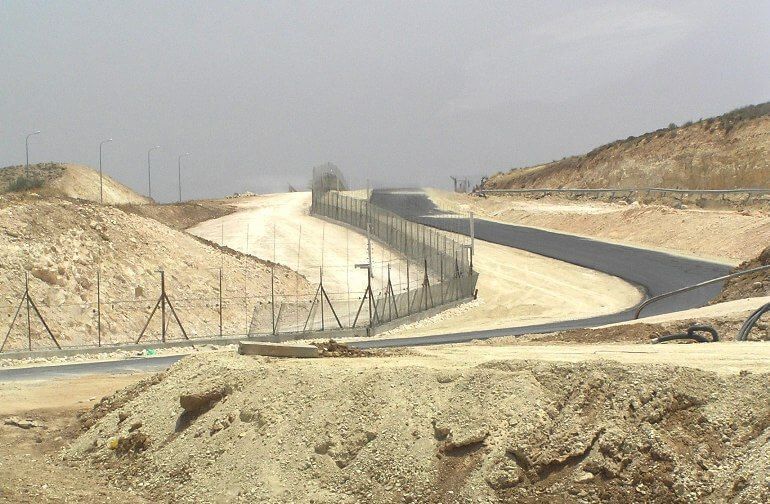
Media reports commonly portray the security barrier as a huge, ugly, concrete wall winding through the West Bank. This, however, is a distortion.
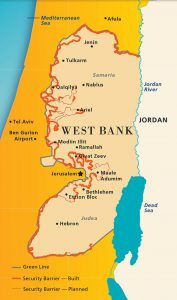
The original proposed route of the security barrier was over 700 km long. To date, only 60 percent of the route has been completed due to budgetary, political, and legal constraints. Of the 465 km of the barrier currently built, only 70 km of the barrier is a concrete wall — mainly in highly populated, urban areas, such as Jerusalem, Bethlehem, Qalqiliyah and Tulkarm.
The rest of the security barrier is made up of an electronic wire fence that notifies the IDF when it detects someone trying to cross illegally. In most places the barrier is 160 ft wide, and features ditches and barbed wire to impede crossings, and paved roads for border police patrol vehicles.
The Security Barrier’s Costs, For Everyone
The security barrier was one of the largest infrastructure projects in Israel’s history. Each kilometer of fence costs the government approximately $2 million. So far, more than $2.1 billion has been spent, more than double the expected budget.
No one can argue that the security barrier has not been costly for the Palestinians. Within eastern Jerusalem, the loss of clientele due to the security barrier resulted in the closure of close to 5,000 small businesses.

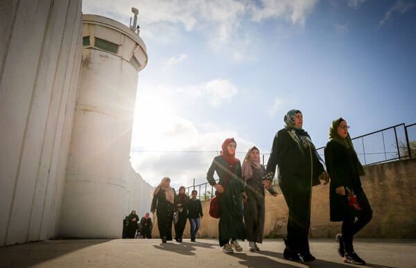
It is also harder for Palestinians living outside the security barrier to enter Israel to work and visit family.
Specifically in Jerusalem, the route of the security barrier has caused hardship for many Palestinian Jerusalemites. The route of the security barrier in Jerusalem does not follow the municipal boundaries. The security barrier’s route has left an estimated 80,000 Palestinians who hold Jerusalem residency cards to be living outside of the security barrier, but still technically within the city’s municipal boundaries. These areas, such as the Qalandiya area in the north of the city and the Shuafat refugee camp northeast of the city, lack the municipal services and emergency services they should be entitled to as residents of Jerusalem.
The security barrier has not cut the West Bank off from Israel. More than 80,000 Palestinians enter Israel daily for work, education and medical care.
The Route, Explained
The route of the security barrier took into account topography, population density, and threat assessment.
Critics claim the security barrier was a pretext for a land grab, using the cover of security in order to unilaterally take land beyond the Green Line. However, this claim ignores the history and relevance of the Green Line.

The Green Line, named for the marker it was drawn with, was originally drawn in 1949 as a part of the General Armistice Agreements between Israel, Jordan, Lebanon, and Syria following the War of Independence.
Crucially, the Israeli and Arab negotiators did not draw the Green Line with topography in mind. Its original demarcation reflected the Israeli and Arab positions immediately following the War of Independence. Conventions signed with Egypt, Jordan, and Syria all contained clauses stating that the ceasefire lines were not to be taken as the final borders of the State of Israel.
To quote the Israel-Jordanian Armistice Agreement (emphasis added)
The provisions of this article shall not be interpreted as prejudicing, in any sense, an ultimate political settlement between the Parties to this Agreement.
The Armistice Demarcation Lines defined in articles V and VI of this Agreement are agreed upon by the Parties without prejudice to future territorial settlements or boundary lines or to claims of either Party relating thereto . . .
The Armistice Demarcation Lines defined in this article and in article V shall be subject to such rectification as may be agreed upon by the Parties to this Agreement, and all such rectifications shall have the same force and effect as if they had been incorporated in full in this General Armistice Agreement.
In other words, the Green Line was never meant to be a final border between Israel and any Arab states or any future Palestinian state. However, the Green Line is incorrectly — and perhaps illegally — treated like the optimal border between Israel and the Palestinians.

Many are critical of the security barrier’s route specifically where it runs through Jerusalem. According to Dr. David Koren, leaving certain Palestinian areas, such as the Shuafat refugee camp and Kfar Akev, outside the security barrier is due to multiple reasons:
- The Shuafat Refugee camp is managed by UNRWA, which is supposed to be responsible for handling Palestinian refugees.
- Terrain made it impossible to build the barrier in between Kfar Akev and southern Ramallah.
- Palestinian population density would have posed a severe tactical limitation for Israeli security personnel, and lead to more violence.
Is it Worth the Cost?
The simple answer: Yes.
Since the construction of the security barrier began, the number of terror attacks originating from the West Bank has decreased by more than 90 percent. In 2002, 457 Israelis died from terrorist attacks. By 2009, eight Israelis died from terrorist attacks.
Every country has the right to defend itself. For Israel, the security barrier has worked in stopping terrorist attacks.
For critics who still question the effectiveness of the security barrier, who better than a Palestinian terror chief to provide confirmation? In 2006, the head of Palestinian Islamic Jihad, Ramadan Salah told Hezbollah’s Al-Manar TV, “For example, in the West Bank, there’s the separation wall, which is an obstacle for the resistance [terror]. If it did not exist, the situation would be completely different.”

