Key Takeaways:
-
Drone footage from Gaza is far from objective — operators strategically manipulate angles, altitude, lighting, and cropping to exaggerate destruction and exclude functioning areas, creating a distorted narrative of total devastation.
-
Civilians, including children, are repeatedly placed in hazardous rubble zones for staged photo-ops, raising serious questions about who organizes these scenes and how they are used to manufacture sympathy and reinforce anti-Israel messaging.
-
The imagery systematically omits critical context, such as intact neighborhoods, functioning infrastructure, and the role of Hamas’ tunnel network — turning drone visuals into powerful propaganda tools rather than neutral documentation.
Drone footage has become the most influential visual currency of the Gaza conflict. It appears authoritative. It appears neutral. It appears to reveal the whole picture.
In reality, no other form of imagery in this war is more operator-controlled or more editorially shaped than the aerial frame.
From altitude to angle, from cropping to color, from the timing of flights to the deliberate exclusion of surrounding normality, Gaza drone footage is built through a visual language that most viewers never notice.
What looks like objective documentation is often a constructed emotional product designed to communicate devastation, despair or accusation. The drone shows not what is, but what the operator chooses to show and what the publishing outlet decides to amplify.
This investigation challenges the myth of drone objectivity.
It shows how aerial images become narrative weapons, shaping perceptions of Gaza by technical choices that are anything but neutral.
⸻
1.
Forensic Analysis
This aerial image shows long communal Iftar tables placed in a narrow corridor of rubble inside the Nuseirat refugee camp. The tables form a straight geometric line through a destroyed streetscape. Multiple surrounding structures show partial collapse, compromised floors, and exposed rebar.
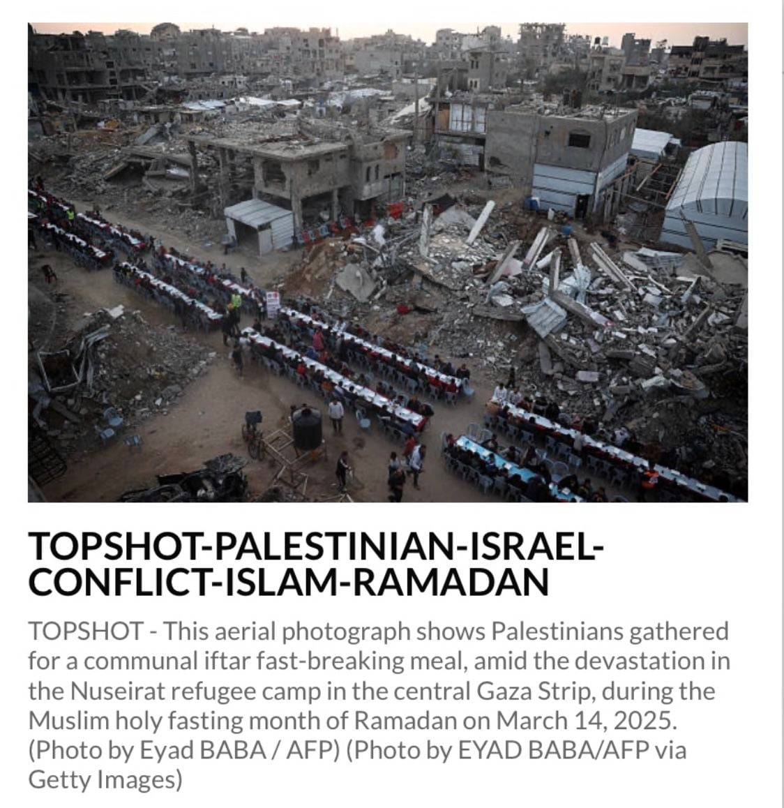
The location selected for the meal is not neutral. It requires civilians, including women, children, and elderly individuals, to enter and remain within an active risk zone:
- Structurally unstable buildings flank the scene.
- Debris fields contain sharp metal, concrete fragments, and potential unexploded hazards.
- Access roads into the area appear narrow or blocked, indicating controlled entry.
The positioning raises serious questions about who authorized access, why this exact corridor was chosen, and how hundreds of civilians were moved in and out of a high-risk environment. Nothing in the frame suggests an organic public gathering. The layout is too orderly, too symmetrical, and too logistically engineered, given the surrounding instability.
Photographic Technique Analysis
The photographer employs multiple construction strategies:
- Mid to high altitude framing
Reinforces the impression of total devastation while preventing visibility of safer or alternative areas outside the cropped corridor.
- Directed symmetry
The straight Iftar line produces an intentionally theatrical contrast, ritual foregrounded against curated ruin.
- Edge cropping
The drone is positioned so that viewers cannot assess safe exits or wider functioning zones; only the tight slice of devastation is shown.
- Gray sky timing
Choosing an overcast moment removes color warmth and increases the perceived severity of the environment.
- Human density as an emotional scale
Crowded tables amplify the perceived proximity between civilians and structural danger.
Risk and Access Logic
The scene cannot occur without:
- Pre-cleared access routes into a hazardous zone
- Permission from the controlling authority
- Logistical staging, including tables, chairs, sound systems, and signage
- Crowd movement coordination and exit planning in an active conflict environment
The image, therefore, documents not only an Iftar, but the deliberate placement of civilians into a high-risk environment for photographic effect.
⸻
2.
Forensic Analysis
This image shows a long communal Iftar table arranged through the center of a devastated street in Gaza City’s al Shujaiyya neighborhood. The scene is framed from a high elevated point to emphasize the scale of destruction surrounding the gathering.
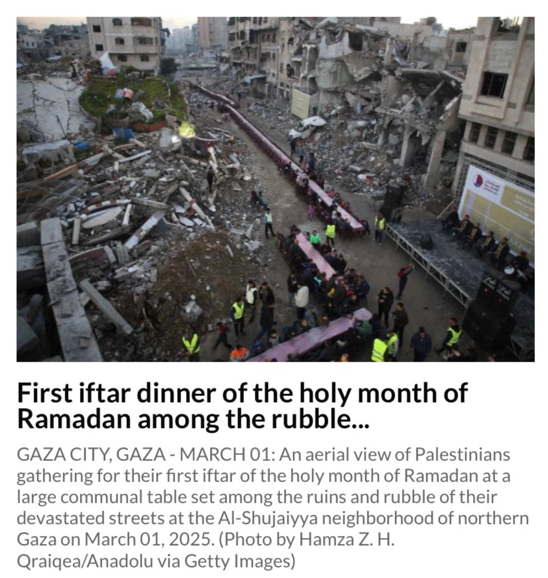
Large sections of the street remain uneven, unstable, and littered with debris. Access to this location requires navigating collapsed structures, loose rubble, and sharp concrete fragments. People in high-visibility vests appear at several points along the table, suggesting coordinated staging, crowd control, or logistical management.
While the caption presents the scene as a community resuming religious rituals among the ruins, the visual reality highlights that this is an active war zone environment, not a safe civic space. The placement of families inside a structurally dangerous corridor of destroyed buildings raises questions about who determined the location and under what level of compulsion or direction.
Photographic Technique Analysis
The photographer uses a high downward angle to create a dramatic linear composition. The long table becomes a visual spine cutting through the rubble. This angle maximizes the vertical walls of destruction around the gathering.
Additional techniques visible in the frame include:
- Symmetrical framing of the table to imply collective unity and resolve
- Foreground rubble and mid-ground diners layered together to reinforce a narrative of resilience set against devastation
- Extended depth of field that keeps both the table and the damaged buildings sharply in focus so that destruction dominates the emotional reading
- A subtle bias toward gray tonal values, whether natural or graded, which enhances bleakness and contrast with the more colorful vests and tablecloths
This is a carefully crafted visual message. The community is small compared with the vastness of destruction surrounding it.
Risk and Access Logic
This location is visibly hazardous. The vertical slabs, fractured flooring, and loose debris fields suggest a structurally compromised zone with potential for collapse, dust inhalation or secondary injuries. Bringing civilians, including children, into such an environment for a communal meal would not occur organically.
This raises three critical questions:
1. Who arranged the access and gathering point?
Natural civilian movement rarely flows into the most structurally dangerous corridor of a destroyed neighborhood.
2. Were participants instructed or encouraged to assemble here?
The synchronized table layout and number of people indicate planning and coordination.
3. Was the photographer granted exclusive safe passage?
High vantage point shots require controlled access and operational permission, especially in a rubble zone.
These factors align with known Gaza media control patterns. Access is facilitated when the resulting imagery benefits narrative objectives.
⸻
3.
Forensic Analysis
Two aerial images show several hundred schoolchildren arranged in tightly controlled formations outside temporary tent classrooms positioned beside Harun al Rashid School. The drone altitude is deliberately low to mid, giving visual weight to the children in the foreground.
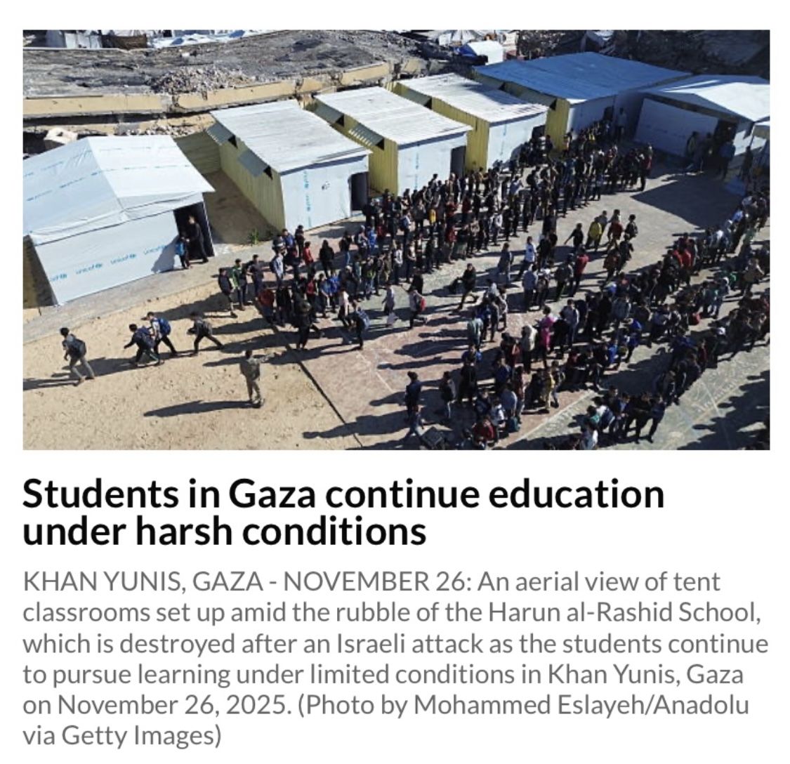
The shaped lines of pupils, forming curves and parallel bands, indicate intentional arrangement rather than spontaneous movement. Their symmetrical positioning reinforces a narrative of education amid devastation, using visual order to heighten emotional contrast.
From a photographic perspective:
- The downward camera angle of roughly 35 to 45 degrees ensures rubble dominates the frame, while undamaged areas outside the scene are excluded.
- Strong midday sun and clear shadows reveal warm and stable conditions rather than the harsh weather often implied in captions.
- Tent classrooms, some branded with UNICEF, are centrally placed to reinforce symbolic cues of dependency and crisis.
- The safety contradiction is stark. Hundreds of children are positioned in an active war-damaged zone that would normally be restricted because of structural instability and unexploded ordnance risk.
The combined effect signals a visually engineered scene, organized, symmetrical, and highly photogenic, yet set in a location that would typically be considered too dangerous for schooling. These two images serve as strong evidence of drone-based narrative construction, not neutral documentation.
⸻
4.
Forensic Analysis
This aerial image shows Yarmouk Stadium, once used for sports and public events, now filled with temporary shelters. The caption presents the scene as a humanitarian consequence of two years of Israeli attacks, yet the photograph also reveals critical contextual elements that the caption does not mention.
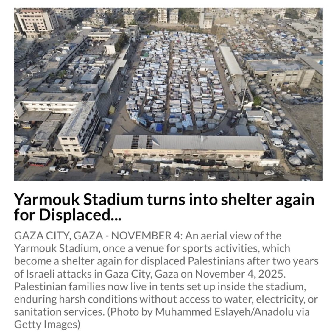
From a photographic forensic perspective:
- The drone is flown at a mid elevation, not high altitude, allowing the operator to compress the stadium interior and prevent adjacent functioning streets from diluting the narrative.
- The framing is deliberately symmetrical and centered on the oval interior, reinforcing the idea of a sealed, contained humanitarian crisis.
- The surrounding buildings appear partially intact, but the frame excludes many of the functioning structures immediately around the stadium. The chosen angle ensures that the tents fill the visual field and amplify scale.
- The stadium is accessible only through controlled entry points, meaning the people inside had to be moved into an exposed zone in an active conflict environment, a central inconsistency never addressed in captions.
- The overall color balance leans toward cool and desaturated tones, which heighten the emotional interpretation of bleakness.
From a narrative standpoint, this is a constructed visual assertion, not a complete documentary truth. The image emphasizes mass displacement while concealing the operational context. Tents placed inside an exposed stadium in a live conflict zone raise questions about who organized it, why this site was chosen, and whether civilians were directed into a structurally unsafe location.
The caption’s claim of “harsh conditions without access to water, electricity or sanitation services” is not supported by the visual evidence.
Visible vehicles and widespread mobile phone use contradict the notion of total infrastructural collapse.
⸻
5.
Forensic Analysis
This drone image looks north along Gaza City’s coastline. The caption describes the scene as Gaza’s former tourist coast that has now turned into a shelter for the homeless. That wording directly clashes with years of international coverage and NGO rhetoric that framed Gaza as the world’s largest open-air prison or a concentration camp long before the current war. It cannot simultaneously have been a tourist coastline and a prison. The caption quietly rewrites the past to heighten the emotional impact of the present.
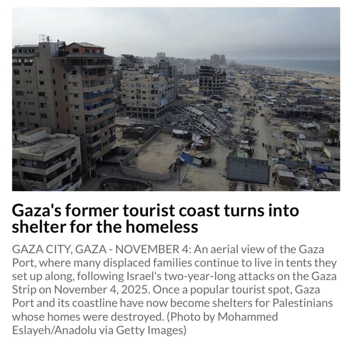
Visually, the drone is flown at medium-high altitude and pitched at a shallow diagonal, creating a sweeping recession from the dense and damaged foreground to the pale strip of beach and sea. The composition forces the viewer to read a single narrow corridor of destruction and tents as representative of the entire coastline.
Clusters of tents and temporary structures are visible close to the beach, set among both damaged and partially intact concrete buildings. The frame excludes most of the inland urban area and any functioning infrastructure beyond this corridor. That selective exclusion is the key photographic choice. The viewer is never allowed to see what lies just outside the lens, only this carefully curated band of ruined tourist coast that serves the narrative of total transformation and loss.
⸻
6.
Forensic Analysis
This aerial image shows the area around the Rashad Shawa Cultural Center in Gaza City. The building and its surroundings are damaged, while temporary shelters fill the open space around it. The visual message is deliberate. This is not an anonymous structure. It is presented as a cultural landmark now surrounded by displaced families.
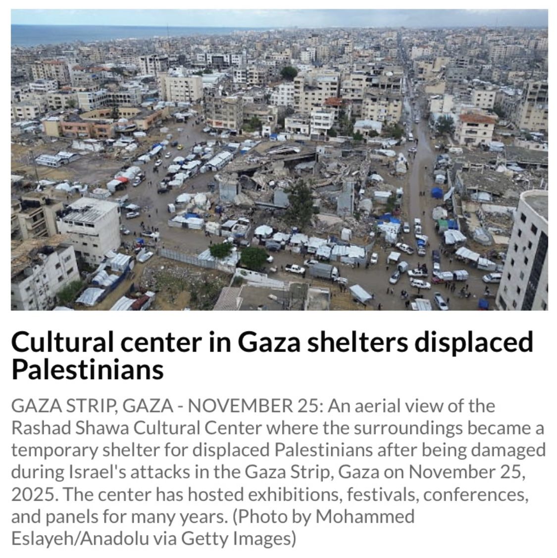
The caption stresses that the center has for many years hosted exhibitions, festivals, conferences, and public panels. That wording is carefully chosen. By highlighting the building’s cultural history, the photograph invites the viewer to see the damage as an attack on civilian life, education, and culture rather than as one site among many in a wider conflict.
This fits a clear pattern in the drone series. Editors repeatedly choose emotionally loaded civic locations, including schools, stadiums, a former tourist coastline, and now a cultural center. Each is selected because it already carries symbolic weight in the viewer’s mind. The choice of subject does as much work as the damage itself.
There is also a deeper contradiction exposed by this caption. For years before the war, Gaza was widely described in international media and NGO campaigns as an open-air prison with little freedom of movement or normal public life. Yet the same caption now describes a venue that regularly hosted exhibitions, festivals, conferences, and discussion panels. Both framings cannot be true at the same time. The drone photograph, therefore, does more than show rubble. It quietly reveals how narratives are adjusted to suit the emotional needs of the moment.
From a visual standpoint, the drone height and angle compress the damaged buildings, tents, and dense urban grid into a flattened field. This makes it difficult for the viewer to separate what is temporary from what is permanent, or what is severely damaged from what is still standing. The eye reads the entire area as uniformly overwhelmed, which is precisely the effect the composition is designed to achieve.
⸻
7.
Forensic Analysis
This drone image of Al Saraya Square continues the pattern already established in the preceding sections — the deliberate selection of emotionally loaded civic locations such as religious communal gatherings, schools, a stadium, a cultural center, and symbolically charged public squares. Each chosen landmark carries symbolic weight, allowing the imagery to suggest that the core pillars of civil life have been uniformly devastated. The visual strategy remains consistent. Recognizable public spaces are used to amplify emotional resonance and to imply total societal collapse.
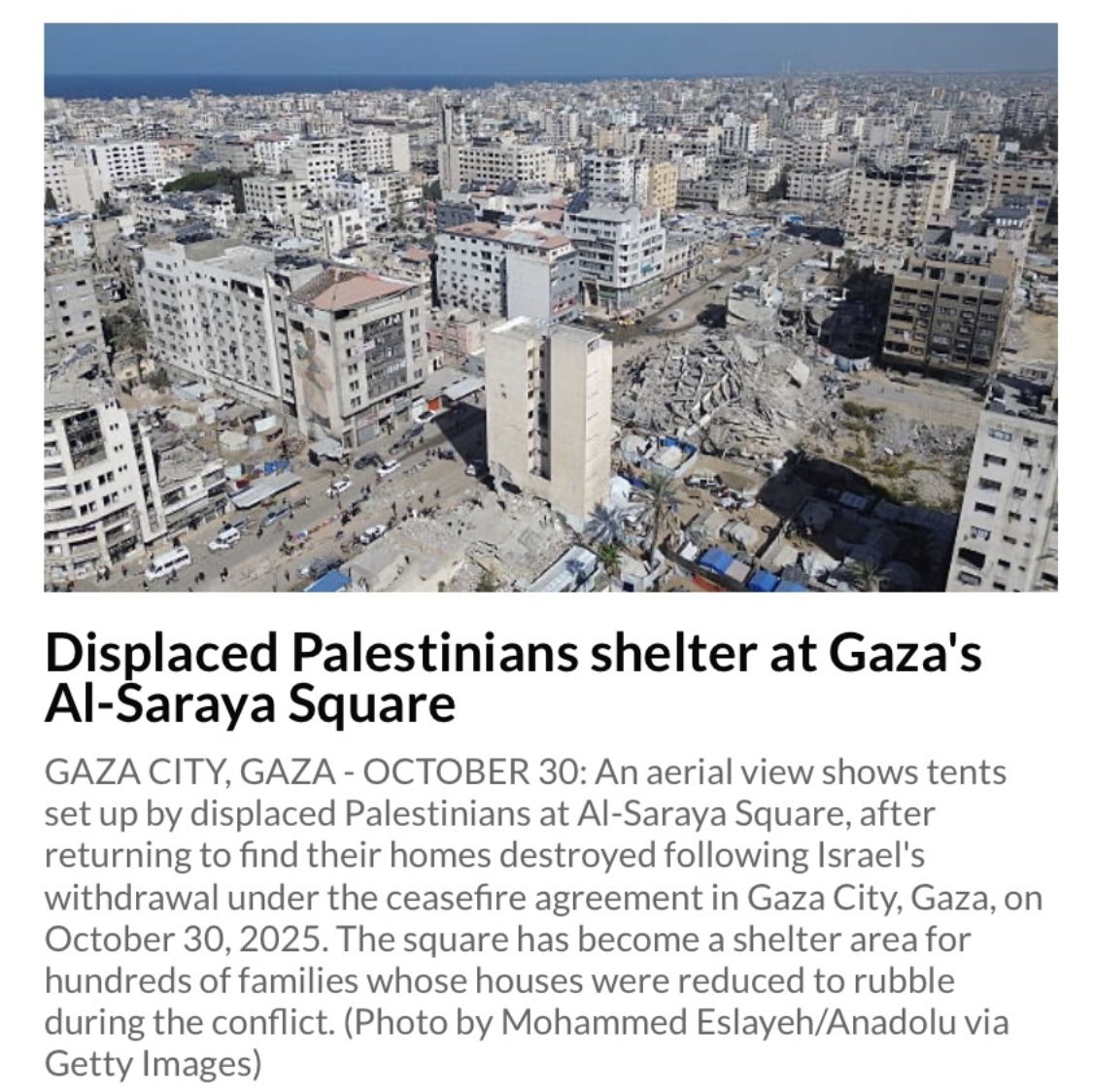
The frame places a single major ruin in the lower right quadrant and uses it as the dominant emotional anchor. This is set against a wide backdrop of largely intact, multistory residential and commercial buildings with visible balconies, windows, and continuous urban density. The altitude is calibrated to exaggerate the scale of devastation while still keeping the selected ruin as the visual centerpiece.
The caption claims that Al Saraya Square has become a shelter area for hundreds of families, yet the visible evidence shows a limited number of tents and temporary structures scattered across the ground. Roadways around the square remain active, with vehicles and pedestrians moving freely. This contradicts the implication of a space overwhelmed by displaced populations.
This follows the broader pattern seen in the series. Symbolic civic spaces are selected, a single cluster of damage or tents is isolated and then framed as representative of the whole, regardless of what the surrounding built environment actually shows.
⸻
8.
Forensic Analysis
This aerial photograph of the Old Gaza Cemetery uses asymmetry as its primary emotional engine. The photographer positions the camera at a high diagonal so the frame tilts visually to broken tombs in the foreground. This steep compositional gradient creates a psychological fall from the living city into a landscape of destruction and prompts the viewer to feel that devastation is expanding outward from the cemetery toward civilian life.
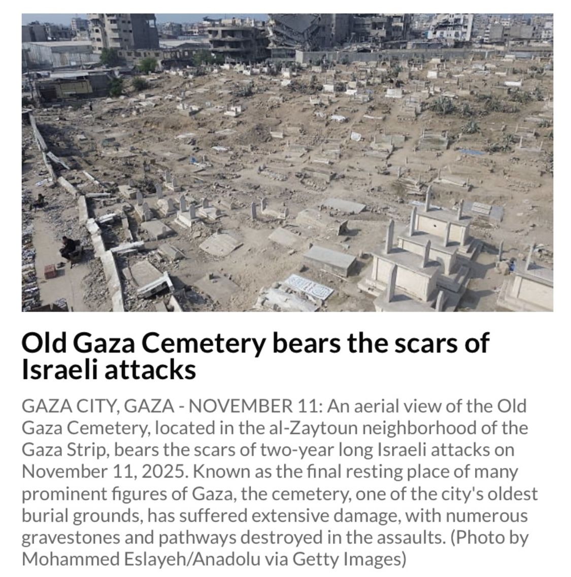
The cemetery itself is selected for its maximum symbolic charge. As a resting place of ancestors, heritage, and communal identity, damage here carries heavier emotional weight than rubble from ordinary streets. This mirrors the pattern across all eight images — a deliberate focus on emotionally loaded civic landmarks, including schools, stadiums, cultural centers, religious gatherings, tourist zones, and now burial grounds. None of the chosen sites is neutral. They are chosen for their capacity to amplify emotional interpretation rather than provide balanced spatial context.
Crucially, the image, like the others, omits any reference to the subterranean tunnel network beneath Gaza, which is directly relevant to ground instability, collapse patterns, and the scale of surface damage. This omission is consistent across Anadolu’s drone and aerial sets and forms part of the visual narrative strategy documented throughout this article.
⸻
Conclusion
Across all of these drone images, the pattern is the same. The footage is constructed, not simply found.
Viewers are shown rubble and not recovery. Gray light and not the bright sun that also exists. Selective ruin and not the functioning streets that lie just beyond the frame. A short flight becomes a sweeping visual judgment about an entire territory.
These frames are not neutral aerial documents. They are narrative objects, controlled visual statements that are designed to evoke sympathy, assign blame and reinforce existing political messages.
What is left out is often more important than what is included.
The functioning neighborhoods nearby.
Market activity just beyond the crop.
Operational context, such as tunnel shafts or controlled demolitions.
The real weather and light that are narrowed down into a single gray moment.
Drone footage has become one of the most persuasive tools in the global information war. To restore visual integrity and challenge false or distorted narratives, audiences and editors alike must learn to read these images for what they are. They show one chosen slice of reality, not the whole.
The truth is not at altitude.
The truth lives in the context that was deliberately left outside the frame.
[/sc]